


Ligonier Valley Rail Road Newspaper Articles
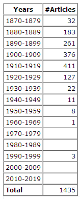 We have compiled over 1,400 newspaper articles that mention the Ligonier Valley Railroad, or related subjects. The articles were originally published starting in 1873 and our collection runs through 1995. Enjoy!
Pittsburgh Post Gazette
Sunday, November 30, 1924
World’s Deepest Gas Well Uncovers New Field Near Ligonier
200.000 Cubic Feet Produced Daily After Sinking Shaft One and Four-tenth Miles – Required 31 Months and Cost $150,000
What is said to be the deepest producing gas well in the world has been sunk in heretofore unexplored sands under Chestnut Ridge, near Ligonier, where the Peoples Natural Gas Company has uncovered a supply of natural gas, it was announced yesterday.
The pay sand was struck at a depth of one and four-tenths miles. The well is known as Booth & Flinn Well No. 2. Thirty-one months of unceasing day and night drilling that began on April 5, 1922, were required to sink it and $150,000 was invested in prospecting for the new fuel supply. The well is now producing 200,000 cubic feet of gas a day. The rock pressure is estimated at 3,700 pounds per square inch, as compared with the average pressure of 240 pounds in ordinary drilling.
Gives New Supply.
Drilling to such extraordinary depths was prompted by the efforts of the company to find fresh supplies of fuel for its consumers after it had become evident that all present known gas-bearing sands were being depleted, it was explained by John B. Tonkin, vice president and general manager of the Peoples Natural Gas Company.
Well No. 2 is the third deep drilling operation in the Ligonier section. Another was drilled during 1919 and 1920, reaching down almost a mile and one third of 6,822 feet. Production is now 160,000 cubic feet daily although gas first came at the rate of 450,000 cubic feet.
In referring to these two wells Mr. Tonkin said: This new deep well and the one completed in 1920, while not large, have fully justified our faith that we might find a new supply of natural gas by deep drilling.
The well-known gas seams in the Pennsylvania and West Virginia fields have been pretty well known and explored for the past 3 or 40 years and the drainage has been known to have been going on for that time. On this account our company has been making extraordinary efforts to develop a source of supply in a virgin sand at greater depths.
About 1913 we drilled a well on the Geary farm, near McDonald, Washington county, at a depth of 7,248 feet and found what was believed to be the Oriskany sand, but it was unproductive and flooded with salt water.
In March, 1919, we commenced a well on the Booth & Flinn tract, the location having been selected by Dr. I. C. White, state geologist of West Virginia for the past 25 years, and completed a year later at 6,822 feet in what is probably the Oriskany sand. The well for a while produced about 450,000 cubic feet of gas and at the present time is delivering about 160,000 cubic feet.
One Well Abandoned.
A deep well was then started on the Seger Brothers’ tract, 4,500 feet northwest, which from almost the start had a crooked hole and which a number of times was straightened only to again give trouble by going crooked. After working on this well for about four years we decided to give up the attempt as the formation was such that we believed we were wasting money in trying to reach the gas sands. We are now abandoning this well, which at one time reached a depth of 6,980 feet.
The recent well, No. 2, on the Booth & Flinn tract, was located only 515 feet from the producing well. It encountered the same sand at about 6,807 feet. The sand proved to be 260 feet thick, but the formation was so hard that it seemed gas could not penetrate and we then decided to go deeper, finally reaching gas at 7,420 feet in what is probably the Stormville or Coeymans sand.
Well No. 2 holds the world’s record for drilling in more than one light. It has considerably more than a mile of solidly welded casing five inches in diameter by one-half inch thick. The exact length is 6,800 feet and about 78 tons of steel were required to make it. This is three times longer than the average casing.
The United States Geological Survey developed some interesting information in the process of drilling the well. Temperature tests were taken at various stages which showed the various strata to be considerably warmer as the well proceeded to the earth’s center. At 1,000 feet the temperature was 63 degrees, 78 at 2,000 feet, 93 at 3,000 feet, 107.8 at 4,000 feet, 127.4 at 5,000 feet, 148 at 6,000 feet, 158 at 6,500 feet and 166.1 at 6,760 feet when the readings ceased.
Hard Sand Encountered.
According to Dr. C. E. Van Ostrand, physical geologist of the United States Geological Survey, these temperature tests indicated the various formations to be in such a position that it was conclusive that at some time a great force exerted from the east had tilted the mountains of Chestnut Ridge considerably westward.
The sands encountered from time to time were declared to be the hardest ever drilled into. Samples of the Oriskany sand, which was the last hard formation pierced, were brought to the surface and they were found to cut glass. About 25 minutes was the life of the end of the drill bit when drilling in this sand. Bits last from six to eight hours in ordinary drilling. Progress through the Oriskany sand was exceedingly slow. Toward the last one foot a day was considered good speed.
Another interesting geological fact uncovered in connection with the sell was that the disturbance that probably tilted Chestnut Ridge at the same time pushed the Pittsburgh coal vein to a height about 1,600 feet above the present earth’s surface. The fact that erosion has eaten away the coal then pushed to the earth’s surface and about 1,600 feet of formation under it is an indication of the inestimable number of years ago the disturbance occurred.